Satellite Tracking
Why did animal X stop transmitting?
Teddy - UNH Large Pelagics Research Center - 2009 Cape Cod Leatherbacks
A project of Large Pelagics Research Center, UNH.
Static Map | Zoom Map | Animated Map (KB)
Subscribe to Project Updates
Background
On 27 August, 2009, we tagged a sub-adult leatherback in Nantucket Sound off Cape Cod, Massachusetts, USA. This turtle was short but stout and had clearly been finding and consuming an abundance of local jellyfish! We named "Teddy" for the late Massachusetts senator Edward "Ted" Kennedy, a fellow enthusiast of Nantucket Sound who devoted the greater part of his life to helping the most vulnerable among us.
After departing Nantucket Sound, Teddy spent almost a month on Nantucket shoals. This productive area was also a leatherback hotspot in 2008 where we observed an abundance of jellyfish. Teddy then spent time in an area SW of Block Island that was also used by Bruce and Ethan. Teddy began to migrate S/SW on the shelf in mid-October, making use of the shelf break, slope waters and canyons enroute. Teddy entered Gulf Stream waters in early November and followed the Gulf Stream E/NE to just south of the New England Seamounts before circling back and re-entering the Gulf Stream. Teddy then moved through the Gulf Stream and has followed a path remarkably similar to that taken by Bruce.
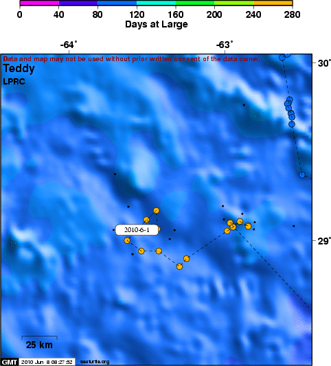
Teddy has been spending the winter N/NE of South America on the edge of a large cold-core ring (see close-up map of track). Cold-core (cyclonic) rings are dynamic ocean features associated with enhanced productivity, so Teddy may be finding good foraging opportunities.
- The presentation of data here does not constitute publication. All data remain copyright of the project partners. Maps or data on this website may not be used or referenced without the explicit written consent of the data owners.
- For more information please visit the project website.
- This map connects positions generated by the ARGOS system designated as location class (lc) '3', '2', '1', '0', 'A', 'B'. Locations that have been "filtered" are displayed as small red dots.
- This maps also shows locations of class 'A' as small black dots which are not connected by a route line.
- Bathymetry layers are derived from the GEBCO One Minute Grid.
- Sea surface temperature and chlorophyll are derived from NASA's Ocean Color data.
- Ocean currents and sea surface heights are derived from AVISO's Ssalto/Duacs Gridded Absolute Dynamic Topography & absolute geostrophic velocities data.
SEATURTLE.ORG collaborates with Argos to help scientists and conservationists manage and analyse their valuable animal tracking data.


| 


