


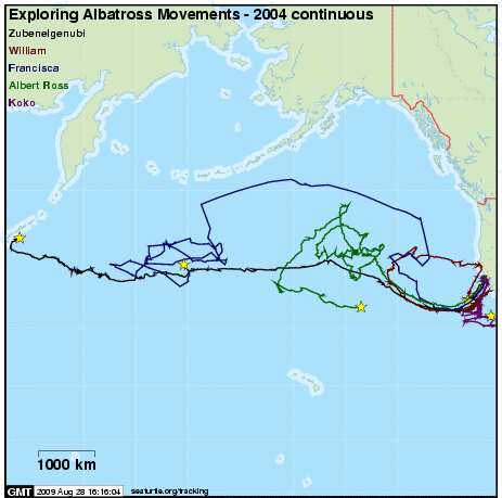
Exploring Albatross Movements - 2004 continuous
A project of Albatross Conservation Collaborative in conjunction with the partners and sponsors detailed below.
Subscribe to receive daily project updates
| Name | Species | Life Stage | Release Date | Last Location | Days Transmitted |
|---|---|---|---|---|---|
| Albert Ross | Black-footed Albatross | plumage class 2 | 2004-08-08 | 2004-10-04 | 57 |
| Francisca | Black-footed Albatross | plumage class 3 | 2004-07-26 | 2004-09-16 | 52 |
| Koko | Black-footed Albatross | plumage class 2 | 2004-08-08 | 2004-09-10 | 33 |
| William | Black-footed Albatross | plumage class 2 | 2004-08-09 | 2004-09-20 | 42 |
| Zubenelgenubi | Black-footed Albatross | plumage class 2 | 2004-08-08 | 2004-09-27 | 50 |
Click on an animal's name for maps and more information.
Introduction

|
The "Exploring Albatross Movements" program seeks to assess the conservation status of the Black-footed Albatross (Phoebastria nigripes), during the post-breeding dispersal period (July - October).
We are using satellite tracking and remote sensing to identify important foraging grounds and habitats defined by seafloor depth and water properties (e.g., sea surface temperature, ocean productivity).
We deployed 9 tags during the summer (July - August) of 2004 to track the fall migration from California to breeding colonies in the Hawaiian chain. Additional tagging will take place in subsequent years.
"Albatross - continuous" displays telemetry data collected using a continuously operating transmitter. In addition to these five continuous tags, we are tracking several birds using "duty-cycled" tags that operate on a 24 hour ON : 24 hour OFF cycle to save batteries.
Project Partners
"Exploring Albatross Movements" is a collaborative project involving non-profit organizations, academic institutions, and resource-management agencies: Oikonos, Duke University, Moss Landing Marine Laboratories, The Claremont Colleges, and the Cordell Bank National Marine Sanctuary.


Project Sponsors
The Cordell Bank National Marine Sanctuary is providing in-kind support to conduct the tagging cruises, and is collaborating in the outreach and education components of this project.
The National Fish and Wildlife Foundation is funding the first season (2004) of this multi-year project.

