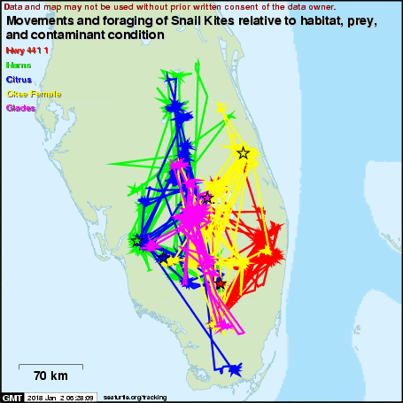
Movements and foraging of Snail Kites relative to habitat, prey, and contaminant condition
A project of USGS and ARCI in conjunction with the partners and sponsors detailed below.
Subscribe to receive daily project updates
| Name | Species | Life Stage | Release Date | Last Location | Days Transmitted |
|---|---|---|---|---|---|
| Citrus | Snail Kite | Adult | 2012-08-12 | 2017-12-26 | 1962 |
| Glades | Snail Kite | Adult | 2012-08-31 | 2017-03-04 | 1646 |
| Harns | Snail Kite | Adult | 2012-03-31 | 2017-12-25 | 2095 |
| Haven | Snail Kite | Adult | 2012-09-03 | 2015-03-14 | 922 |
| Hwy 441 1 | Snail Kite | Adult | 2012-03-07 | 2017-12-26 | 2120 |
| Hwy 441 2 | Snail Kite | Adult | 2012-03-13 | 2015-07-09 | 1213 |
| Okee Female | Snail Kite | Adult | 2012-05-02 | 2017-12-26 | 2064 |
| Okee Male | Snail Kite | Adult | 2012-05-02 | 2015-08-26 | 1211 |
| WCA 3A 2 | Snail Kite | Adult | 2012-08-13 | 2016-01-25 | 1260 |
Click on an animal's name for maps and more information.
Introduction
The Snail Kiteâs (Rostrhamus sociabilis) U.S. distribution is limited to Florida. Snail Kites feed almost entirely on a single species, the Apple Snail (Pomacea paludosa), which is influenced by the timing and distribution of surface water conditions. Striking declines in Snail Kites have been directly tied to human-caused changes in hydrology. The species is listed as Endangered federally and by the state of Florida. Our first satellite-tracking study (2007-2009) determined the differences in cost and effectiveness between satellite and VHF radio telemetry for locating marked Snail Kites following dispersal, for describing habitat use and home ranges, and for estimating survivorship. Survival over two years for this small sample (n=10) was 100% based on satellite telemetry, but VHF tracking of the same sample of birds (i.e., each individual carried a satellite and a VHF transmitter) estimated less than 50% survival over the same two-year period. Satellite tracking also produced significantly larger home-range estimates than VHF tracking and revealed short-term/long-distance movements to outlying activity centers that may represent refugia or other vital destinations during declining conditions. In 2012, we deployed satellite transmitters on 12 additional adult Snail Kites to study movements and habitat selection in relation to snail abundance (with UWF biologists), natural versus altered wetlands, toxins (copper and mercury), and proposed wind-farm developments. For this project, the satellite transmitters include GPS receivers capable of 10-15 meter accuracy. Such finely-scaled location data will inform critical management decisions for Snail Kites and the greater Everglades ecosystem.
Project Partners
Kristen Hart, Ronnie Best, Autumn Iversion, U.S. Geological Survey
Ken Meyer and Gina Kent, Avian Research and Conservation Institute
Phil Darby and Bethany Wight, University of West Florida
Ikuko Fujisaki, University of Florida
Bob Frakes, Emily Bauer, and Anthony Sowers, U.S. Fish and Wildlife Service


Project Sponsors
U.S. Fish and Wildlife Service
U.S. Geological Survey
Saint Johns River Water Management District
South Florida Water Management District
Microwave Telemetry, Inc.